Croaghaun is the most westerly peak of Achill Island, and its highest mountain. There are cliffs on the northern slope of the mountain.
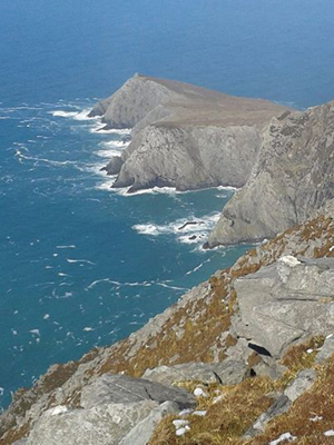
The cliffs can only be seen by hiking around or to the summit of the mountain, or from the sea. They are part of a group of sheer rock faces which start south of Keem Bay and loop around the north-west of the island and east to Slievemore, occasionally dropping vertically into the waters of the Atlantic Ocean. It is common to see shoals of Bottle-nosed Dolphins and Basking sharks. There have been sightings of Porpoises, Killer whales and humpback whales.
A good starting point for your climb is a couple of kilometres outside of Dooagh as the road starts to climb the lower slopes of Croaghaun, watch out for a right turn marked with a signpost for the water treatment plant. Follow this road to the small car park beside Lough Acorrymore. From the car park, walk back in the direction you came from for a couple of hundred metres before leaving the road and climbing along the southern side of Lough Acorrymore. Follow the obvious shoulder in a westerly direction to where the ground levels out. From here, cross a broad plateau before starting into a final short steep climb up to the summit of Croaghaun. It is not until you are nearly upon it that the summit cairn suddenly reveals itself and Croaghaun finally reveals its stunning vista. Standing at the very highest point of the mountain you will see a vast precipice falling over two thousand feet into the water below.
Another route would start from the first car park you reach on the road to Keem Beach, and head up the slope behind the old coastguard station.